
Geography, History & Economy
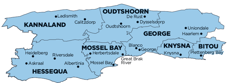
Garden Route District Municipality comprises:
- Bitou Local Municipality
- George Local Municipality
- Hessequa Local Municipality
- Kannaland Local Municipality
- Knysna Local Municipality
- Mossel Bay Local Municipality
- Oudtshoorn Local Municipality
MDB code: DC4
Description: The Garden Route District Municipality is a Category C municipality situated in the Western Cape Province. The name was changed from Eden District Municipality to the Garden Route District Municipality in October 2018. Garden Route District shares borders with four other district municipalities, namely: Sarah Baartman District Municipality in the Eastern Cape, and Overberg, Cape Winelands and Central Karoo District Municipalities in the Western Cape.
The district municipality comprises seven local municipalities: George, Mossel Bay, Knysna, Bitou, Oudtshoorn, Hessequa and Kannaland.
The region is defined as a medium-capacity functional municipality. Garden Route District has a diverse natural resource base. It is marketed with regards to tourism under the internationally acclaimed brands of the ‘Garden Route’ and ‘Klein Karoo’.
Area: 23 331km²
Cities/Towns: Albertinia, Boggoms Bay, Brandwag, Brenton, Brenton-on-Sea, Buffels Bay, Calitzdorp, De Rust, Dysselsdorp, Friemersheim, George, Gouritz, Great Brak River, Haarlem, Heidelberg, Herbertsdale, Herolds Bay, Jongensfontein, Keurboomstrand, Knoetzie, Knysna, Krantshoek, Kurland, Kwanokuthula, Ladismith, Mossel Bay, Nature’s Valley, Oudtshoorn, Plettenberg Bay, Rheenendal, Riversdale, Sedgefield, Slangrivier, Still Bay, Uniondale, Vanwyksdorp, Victoria Bay, Vleesbaai, Wilderness, Witsand, Wittedrift, Zoar
Main Economic Sectors: Finance and business services (23.4%), manufacturing (17.3%), wholesale and accommodation (17%), general government (12.1%), construction (9.5%), transport and communication (7.8%), community services (5.5%), agriculture, forestry and fishing (5.5%)